Whatever became of Snatchup/s End?
Snatchups End was the location of Apsley Mills and was within the parish of Kings Langley for much of the 19th century. The area is now known as Apsley End.
Throughout the archives there are references to an historic part of the parish known as Snatchup/s End – the final ‘s’ is sometimes omitted. For example from the Court Roll of 17 April 1773, ‘Admission of Thomas Sweeting of King’s Langley to property in Chapple croft Lane, Chipperfield (in trust for the inhabitants of the parish), on the surrender of William Child of Snatchups End, King’s Langley, wheelwright.’
One indication of its location is in the Victorian J H Salter’s poem, ‘The Ends of West Hertfordshire’ naming twenty-one ‘Ends’ albeit not a complete list. The relevant part for us is ‘...There’s Snatchup’s End and Frogmore End and Moor End in a row…’.
In the 1891 census John Janaway (55) was running the Wheelwright and Smiths workshop but the Letter or Type Foundry (there since at least 1841) does not appear. Nor in 1891 does the name Snatchups End, for the area is by now becoming known as Apsley End.
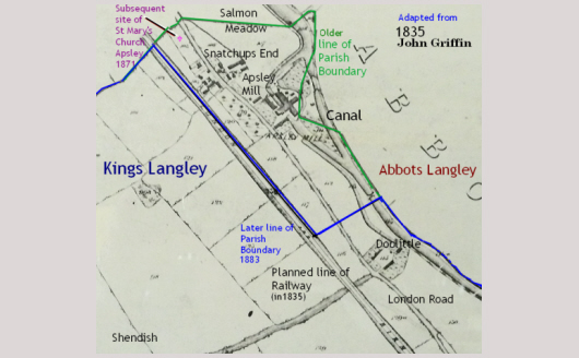
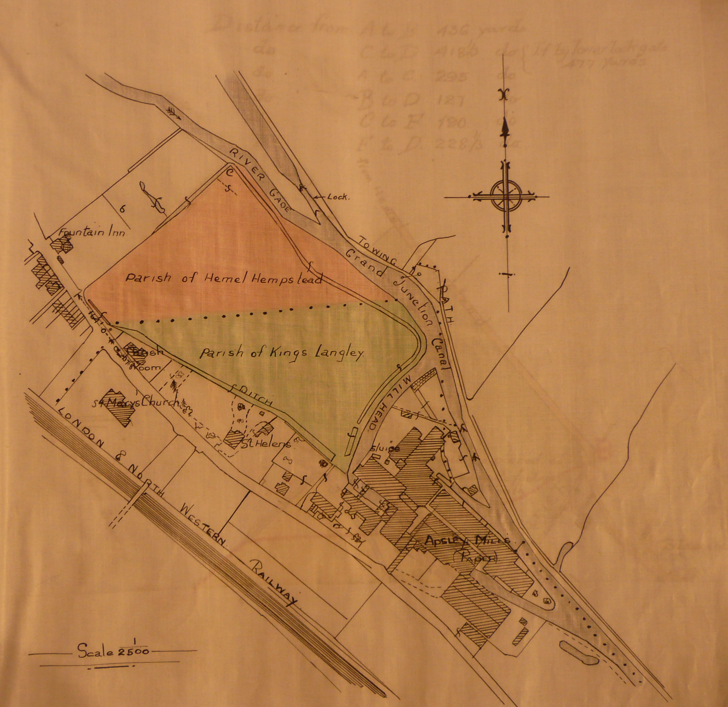
In the 1901 census, however, the enumerator, Mr. Edward Toms, carefully noted that Snatchups End (he reverts to its traditional name) and Doolittle were still in the civil parish of Kings Langley but that Snatchups End was now in the ecclesiastical parish of St Mary’s, Apsley End. Both civil parish and ecclesiastical parish boundaries are subject to change and do not necessarily follow the same demarcation. Later the civil parish boundary would recede to follow the railway line for a short distance towards Kings Langley village conceding the place previously known as Snatchup/s End to what had become the parish of Apsley End. Just beyond what is now Apsley station the civil boundary turns towards the north-east over the main road and down to the canal so as to retain Doolittle in Kings Langley.
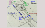
This plan shows the old parish boundary due to be redrawn to follow the railway line after the building of St Marys Church.
John Dickinson, while not a church man himself, was instrumental in the building of Leverstock Green Church. However, he insisted he did not want a church built in Apsley so near to the Paper Mill. It was not until after his death that on 24th June 1869 ‘clergy and the landowners of the property in the neighbourhood of Apsley and Nash Mills met at Shendish. It was agreed, “that it was most desirable to build a church and form a district to provide for the spiritual work and supervision of the neighbourhood.”
A meadow in the occupation of Janaway the wheelwright at Snatchups End was selected as the church site and duly purchased. The new district was to be formed from parts of Boxmoor, Kings Langley, Abbots Langley and Leverstock Green.’ (from ‘The Early History of the Parish of Apsley End’).
In ‘A Short History of the Manor of Shendish’, Alan Penwarden records that, ‘In 1896 four cottages were built at Snatchups End for workers on the Shendish estate. They were designed by Sir Edwin Lutyens and are now listed buildings. A nearby footbridge over the railway was provided for access to the Shendish estate. The cottages were later used by John Dickinson & Co. for their staff.’
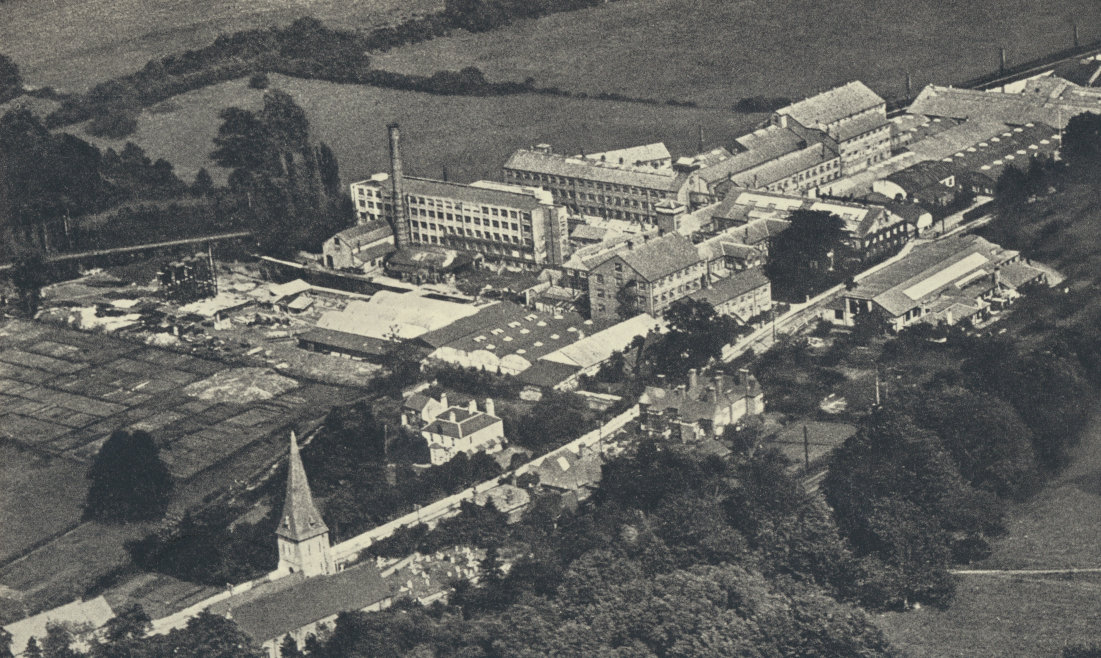
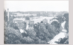
This picture (1920) from ‘The Endless Web’ by Joan Evans shows St Mary’s Church, Apsley End and Apsley Mills. To the lower right of the photo just by a gap in the trees exposing the railway line is the large Lutyens building with the tall chimneys. This is the area including the land now occupied by the church that was previously known as Snatchup/s End.
There is, locally, a Snatchup (road) in Redbourn and a Snatchup Alley in St Albans but so far the name has defied research apart from a suggestion it was where mail bags were snatched up by a passing stage coach. Given the longstanding proximity of a wheelwright business there may indeed be some kind of connection.
Snatchup/s End was, then, once at the most northern part of Kings Langley and its name is of particular note to family historians, especially as it appears in land transactions, parish records and 19th century census returns.
Currently, however, no reference to Snatchup/s End can be found on any recent map. Sadly now it is a case of ‘Address unknown. No such number. No such zone…’
This article was previously published in the KLLH&MS Newsletter No47 March 2009.